MOBILITY MAPS: A Dataset for Open Public Transport Infrastructure and Mobility Accessibility Profiles
M. T. Fischer, D. Fürst, Y. Metz, M. Schmidt, J. Rauscher, D. A. Keim
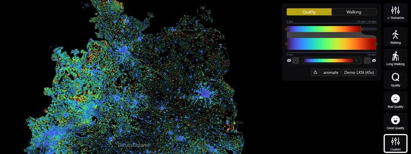
DOI:10.5281/zenodo.14772646, 2025This dataset provides a comprehensive assessment of public transport connectivity across Germany by analyzing both walking distances to the nearest public transport stops as well as the quality of public transport connections for daily usage scenarios with housing-level-granularity on a country-wide scale. The data was generated through a novel approach that integrates multiple open data sources, simulation models, and visual analytics techniques, enabling researchers, policymakers, and urban planners to identify gaps and opportunities for transit network improvements. Why does it matter? - Efficient and accessible public transportation is a critical component of sustainable urban development. However, many transit networks struggle to adequately serve diverse populations due to infrastructural, financial, and urban planning limitations. Traditional transit planning often relies on aggregated statistics, expert opinions, or limited surveys, making it difficult to assess transport accessibility at an individual household level. This dataset provides a data-driven and reproducible methodology for unbiased country-wide comparisons. Find more information at https://mobility.dbvis.de.
Materials


Related Publication